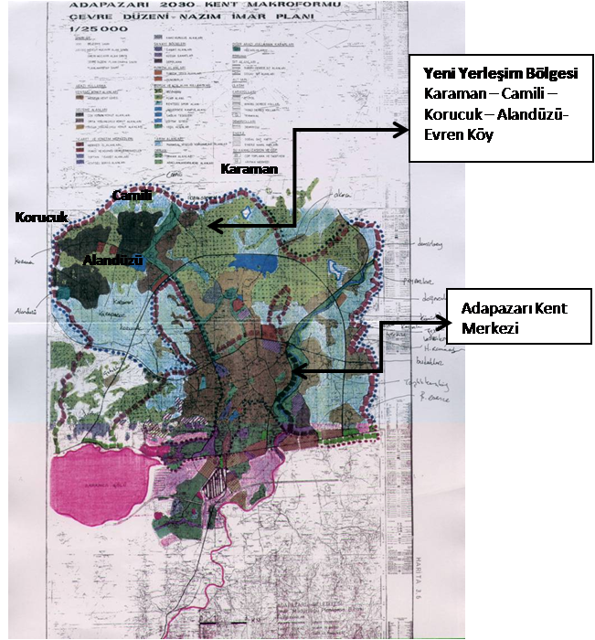
ADAPAZARI 2030 KENT MAKROFORMU ÇEVRE DÜZENİ NAZIM İMAR PLANI ADAPAZARI CİTY MACROFORM OF 1996 AT THE SCALE OF 1:25000, AND THE ENVİRONMENTAL ARRANGEMENT PLAN
2030 City Macro Form Environmental Arrangement Plan at the Scale Of1:25 000 of 1996 (Made by Fikret Bayhan, 1996)
”Bir sonraki büyük depreme kadar ne kadar fazla kişiyi Yeni Yerleşim Bölgesine taşırsak o kadar insanın hayatını kurtarmış oluruz.” FB
Adapazarı City Macroform of 1996 at the scale of 1:25000, and the Environmental Arrangement Plan
Adapazarı City Macro Form and Environmental Arrangement Plan of 2030 prepared by Fikret Bayhan, the City Planner of Adapazarı in 1996, considering the earthquake hazard which was approved by the municipality council in 1998 and sent to the Governorship of Sakarya. In this environmental arrangement plan valid until 2030, it is suggested that Adapazarı should develop toward the settlements of Karaman, Karaman, Camili, Korucuk, Alandüzü and Evrenköy districts located 10 km from the city on the northwest and that are resistant to the earthquakes with no risk of liquefaction. The aim was to reduce the risks of earthquake in the city center as determined according to geological and geotechnical surveys. Although this plan was sent to the Governorship of Sakarya, it was not sent to the relevant ministry and kept pending due several reasons.
Adapazarı city center and new settlement area
The plan at the scale of 1: 25’000 of the region indicates the villages of Karaman – Camili – Korucuk and Alandüzü as new settlements which was imitated by the plan prepared immediately after the earthquake of 17 August 1999 and approved by the Ministry of Public Works. It was according to this plan that 8500 disaster houses were constructed in the region and the plan at the scale of 1:25000 prepared in 1996 was taken finally into effect by being approved with the section of New Settlements